DUASFB 6

Drones are about people, too…

Even if the perception is that some craft are ‘autonomous’, people are still a key part of the system

Welcome to Drone FEEDBACK Edition 6. So, what sort of reports have we seen and are there any trends emerging since the issue of FEEDBACK Edition 5?

Well, we have seen a majority of Human Factors reports of course, but we have now received our first Just Culture report, which we are currently working on. Whilst we do not review it in this issue, we are hoping we can report in full in the next issue of FEEDBACK which will be issued around March / April of 2023. Even if the perception of RPAS is they are becoming more autonomous, people are still a key part of the system and ensuring they are taking account of Human Factors implications and feel they are working in a Just Culture is essential. Do look out for FEEDBACK Edition 7 when it emerges.

The other reports cover a variety of different types of occurrences, but it is interesting to note that the subject of map source data accuracy in the context of geofencing occurs again. There is also another report about publishing design limits, where we could perhaps recommend they are included in what is required for Class (C) marking in the future.

As many of you know, CHIRP has developed and is promulgating the use of a confidential, independent reporting programme for Human Factors “HF” and Just Culture occurrences, or near occurrences, arising from the operation of drones or Remotely Piloted Aircraft Systems (RPAS). The aim is that drone pilots, who are in many cases relatively new to the world of aviation, will be able to benefit from lessons learnt and existing practices that have developed within the aviation sector, over many years, for crewed aircraft. Many of the same theories that apply to crewed aircraft apply equally to aircraft with remote pilots. If all of us can learn from an event that happened to one individual and might happen to another, it is to everyone’s advantage to be able to do so. CHIRP is the conduit for individuals to share their experience of HF occurrences safely and confidentially in a way that enables many others to learn from them. FEEDBACK is CHIRP’s regular publication that seeks to communicate the occurrences we are informed about, draw some lessons, and pass them on to flyers who might benefit. We hope you find them useful.

We would again like to thank those who have taken time to send in a report. Without you, others would have missed out on learning something. We are very grateful to those that have altruistically shared the benefit of their experience. As winter approaches its time to burnish those weather forecasting skills. For those looking to capture inspection and survey data, at least there will be less vegetation obscuring what you are trying to look at!!

Rupert Dent, Drone/UAS Programme Manager

  • DUASxxx4

    Safety Management Systems
    Safety Management Systems

    [Company] have shared this occurrence publicly in the hope all drone operators can benefit from their experience and to fully advocate the promotion of a ‘just culture’ within their respective organisations. By fostering a just culture, [Company] have created an environment in which reporting and learning is becoming a normalised facet of their operation.

    Report text: During a survey flight the Unmanned Aircraft (<2kg MTOW fixed wing UA) ‘land’ function was triggered by the remote pilot due to turbulence and perceived strong winds.

    On return to the take-off and landing point, excessive turns were witnessed until the aircraft veered from side to side. Due to strain on the aircraft a wing detached causing the aircraft to spiral to the ground. Whilst the event was reported (UK CAA & AAIB) and lessons learned including provision of feedback to the aircraft manufacturer; the major learnings were derived from [Company] management of the post-crash and emergency response aspects of the event and the future training implications for their flight operations team.

    [Company] Global Head of Safety goes on to describe the importance of an SMS for growing organisations, and the benefits of having one, especially through the granting by the Irish Aviation Authority (IAA) of their Light Unmanned Certificate (LUC), (which is recognised in all European Union Aviation Safety Agency (EASA) member countries). Speed of reporting feedback, provision of feedback to Commercial Off The Shelf (COTS) Original Equipment Manufacturers (OEM), publication of an occurrence reporting, internal newsletter and the inclusion of aviation expertise in informing the development and management of the process are all key to a transparent and effective SMS.

    Those individuals who are starting out do not need to feel overburdened with the formulation of a complex SMS but should have a simple process in place to report any occurrence that could have led to a serious incident or accident. The data shared with the whole industry is invaluable to ensure we all progress safety forward.

    The pilot in question was asked to give his view on the occurrence and how it was handled. Their response was:

    The UAV crash showed first hand that our documentation was fairly generic and didn’t encompass all possible situations that could have happened. It was concentrated on the worst case scenarios for if the aircraft injured members of the public but wasn’t clear on the step-by-step process to go through for if a minor incident happened. This gap was filled by the Remote Pilot being able to contact relevant safety managers quickly and be guided on the next steps however it was identified that creating more of a structured process would hugely benefit the flight operations team as the department grew. Overall all line manager/safety managers treated this incident with the professionalism as if it were a very serious incident and served as a good testing ground for the procedures which are relevant for any kind of UAV whether it is 1.4kg or 140kg.

    The Operator has been very transparent in sharing this information, which is great to see. The report has an element of Human Factors and Just Culture in operation in it. The element we thought was worth noting was the wing detachment. Crewed aircraft come with an Operators manual that sets out the limitations of the manoeuvres the aircraft can perform whilst remaining within the design limit load factor. Oddly very few if any Drone Operator manuals for the sub-25kg commercially available aircraft seem to contain any of these limits, other than perhaps a maximum airspeed. In the occurrence above, on triggering the Return To Home (RTH) function the aircraft seems to have flown itself at an excessive airspeed, subjecting it to G forces beyond its design limits, such that the wing broke and the inevitable followed. Somewhere in the design of the aircraft the autonomous execution of a pre-programmed command had been set up to take place at a speed that exceeded the structural design limits. We often think about Human Factors issues as just being in the operation of aircraft but here’s a Human Factors issue in the design and compilation of the software!

    We would suggest that the learning here is that C-marking, when it happens, could usefully include elements of design limits being incorporated into the Operators manual, along with information on how any autonomous operations have been calibrated. This will then help the pilot decide whether to trigger an autonomous set of commands or fly a manoeuvre using the sticks.

    Many of today’s production Drones have in-built systems that will warn the pilot via messages on the controller if the aircraft is encountering excessive winds aloft. What pilots should do will depend to some degree on whether the aircraft is rotary or fixed wing. It may of course be to slow down first and then either land immediately or return to the landing spot. An automated RTH feature may be programmed to be executed at a relatively high speed, in which case a hand flown return could turn out to be the best option.

  • DUASxxx5

    Inadvertent switch selection
    Inadvertent switch selection

    [Organisation] show last week. Firstly, I would like to thank everyone who helped to retrieve my [Model Aircraft Type] after the loss of power which resulted in the model landing in the rough grass area, severely damaging the wings. Two pilots I would like to mention are [Pilot 1], and [Pilot 2], many thanks. Sunday morning, I transferred the model from my car to the workshop, and I am relived to say that the fuselage, engine, and all associated equipment is in perfect order, no damage whatsoever. Checking the radial engine I removed the plugs one at a time, switched on the ignition and with one plug connected to its lead and the other four remaining in the engine, holding the prop I turned the engine over and got a full spark. I repeated this procedure until all five plugs were removed, all with a full spark. So, no ignition problems. However, when I was turning the engine over it gave a kick, it did it a couple of times and I thought it must be due to some residual fuel in the cylinders. The tank had been emptied although a small amount always remains. When the model had been retrieved, I switched off all the receiver switches etc, and then the transmitter which I put into the carry case. So, all the switch settings were as the model landed. Wednesday in bed thinking as usual what happened, and then I remembered the engine kicking when I turned it over, and I thought it can’t do that unless the engine is choked. So, 2.30 am in the morning I got out of bed and went into my workshop, took the transmitter out of its case and, low and behold, the servo operated switch was in the on position, and on checking the carb the choke was on. I must have accidentally turned the switch on while flying. This would be the reason for the loss of power. What an idiot I am.

    My transmitter is a Futaba T12 FGA and for 14 years the choke switch has been set on a switch SA which is a 3-position switch and a short lever. However, one flight last year the engine was not at its best, so I landed OK and found that the choke switch was in the middle position, meaning it was partially choked. So, to prevent that happening again I changed it to a 2-position switch SF which is on the top left-hand side and has a long lever. Need I say more!

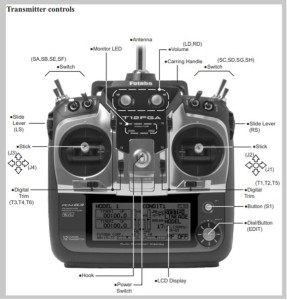
    Human factor analysis at 2.30am is impressive, by anyone’s standards! It did seem to do the trick though, because the reporter discovered the root cause of the occurrence: a switch knocked into the wrong position. Very easy to do, but with significant consequences. The photograph above shows the switches that the reporter refers to in the text. As for manned aircraft, immediate action drills can be useful for time-critical incidents so, if experiencing a sudden loss of power, a check of power source (be it battery or fuel) selectors is a worthwhile action just in case something has been inadvertently moved.

  • DUAS17

    Beware of Google maps
    Beware of Google maps

    I was staying at a camp site in Great Tey which is close to Earls Colne aerodrome and I intended to fly to get some aerial pictures of the site. Before going to the site, I looked it up on Google maps, and then checked that position on Google maps; the business that owns the site is listed on Google maps. Having located the site on Google maps I looked up the same position on the Altitude Angel drone flight planning app and saw that it was about 1km outside of the Earls Colne FRZ, and so safe and legal to fly there.

    On the flying day, I was setting up my drone for the flight, and a colleague who is also a drone flyer pointed out I can’t fly here. In response I checked the Altitude Angel app and realised he was right and that I was a few hundred metres inside the FRZ. I abandoned the flight before taking off or starting motors. The DJI app may also have warned me not to fly there, but I never got as far as starting the DJI control app.

    But the crucial point was that the site on the ground wasn’t where Google Maps showed it – it was some way West, and inside the FRZ. Had my colleague not told me to stop, I might well have attempted the flight. I should also have checked Altitude Angel at site before flying instead of just checking it at home before departure.

    Since this was a near miss, not an incident, I don’t think it warrants a formal occurrence report, but I think the lesson is worth sharing.

    1) Your flying site as shown on Google Maps may not be the place where you are actually flying;

    2) OK to Altitude Angel before you leave home, but also remember to check it from the actual flying site before you fly.

    The pilot in this occurrence initially used the location capabilities of Google to identify a business site as being accurate for the purpose of knowing whether it is inside or outside an FRZ. It is on the face of it a very easy assumption to make. We do not claim to know what Google’s verification processes are as far as the geospatial accuracy of what goes onto their maps is concerned, but there are clearly errors in some instances. If for instance they rely on data input by a business user using a postcode then this can cover a large area and show the map marker some distance away from its real location.

    In previous issues of CHIRP we have explored the topic of the accuracy of geofencing and the depiction of FRZs and danger areas on a variety of Drone manufacturers’ onboard maps. Following discussions with the CAA we understand that this issue will be dealt with when C-marking rules are set out in due course.

    The pilot in question does need to be congratulated for checking his location vis a vis the FRZ when on site. The fact that his colleague alerted him to the possibility of being in an FRZ is also good to see. Sharing information amongst pilots is important!

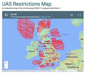
    The final point that is worth making, is that if you are going to use Google for flight planning, then the start point is to access the NATS Aeronautical Information Service: https://www.nats.aero click ‘Airspace’ on the top menu and then select ‘Drones & new airspace users’ where you will find a tile that says ‘UAS Airspace Restriction Maps’ within which all current FRZs are overlain onto a Google map (see diagram) that can be downloaded if required.

  • DUASxxx6

    F4 Scale Phantom crash
    F4 Scale Phantom crash

    From AAIB Bulletin10/2022 (AAIB-27831). A turbine powered model aircraft suffered a loss of control during its maiden test flight. It continued to fly beyond visual line of sight before crashing on a railway track and was subsequently run over by a passing train. Safety actions taken as a result of this accident include publication of enhanced guidance for members by the British Model Flying Association (BMFA). The model flying club also amended its procedures relating to flying turbine powered models.

    The F4 Scale Phantom is a 1:10 scale flying model of the McDonnel Douglas F4 Phantom jet aircraft. It has a takeoff mass of 6.4 kg and is powered by a turbine engine using kerosene. The recently-built model aircraft was undergoing its first test flight. Pre-flight preparation had included an independent check of the control surface sense and deflections, as well as range checks between the transmitter (on the controller) and the receiver (on the aircraft), from multiple angles. A normal takeoff was performed to a height of approximately 200 ft agl, for a flight that predominantly comprised of left hand ‘race-track circuits.’ During the flight the pilot noted that the aileron response was “sluggish”, but he considered it sufficient for safe flight. He subsequently noted that up elevator was required to maintain level flight and progressively applied ‘up’ trim. During a 180Âș downwind turn, the aircraft suddenly veered to the right putting it on a north-west heading. Despite the pilot applying corrective aileron inputs, the aircraft did not respond and control was lost. It subsequently stalled, entered a spin and disappeared out of visual line of sight below a tree line. The model aircraft was later found to have come to rest on a railway track adjacent to the airfield, close to a pedestrian crossing, and was subsequently run over by a passing train. The wreckage was recovered by the pilot and other club members. There were no injuries or damage to property. The model aircraft was destroyed. The pilot considered that he had let the airspeed drop too low while concentrating on applying corrective elevator trim. Airfield information: the model flying club is based at Kenyon Hall Farm Airstrip (Figure 1), which is an unlicensed airfield with a grass Runway 05/23 for full size aircraft. There are two runways for model flying, a 75 m strip adjacent and parallel to 05/23 and a 110 m strip, which runs in an east-west direction. A railway track passes to the north of the site. There are several public footpaths which run along the north-west boundary of the airfield, and in the area between the airfield and railway track.

    Following the accident, collaboration was undertaken between the BMFA and Network Rail’s Air Operations team. This resulted in the provision of tailored guidance for unmanned and model aircraft operators which will be incorporated in the BMFA’s member’s handbook. It included the provision of a 24-hour emergency contact telephone number for reporting railway safety threats, including the presence of people or objects on or near railway tracks. The BMFA also published an article about this accident, and operation in proximity to railways in general, in the July 2022 edition of its member magazine ‘BMFA news’. In addition, the BMFA has updated its incident/accident reporting portal to specifically guide members to telephone Network Rail immediately if an aircraft has come down on Network Rail property, in addition to the requirement to inform the AAIB. After the accident the club amended its procedures to require any turbine powered model to be approved by the club committee before it can be flown at the site, so that its suitability can be assessed. Following this investigation, the club added a section to its procedures relating to retrieval of models that land outside the airfield boundary, which directly references the Network Rail 24-hour emergency telephone number.

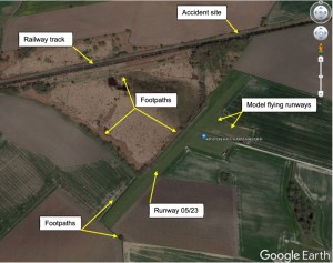
    The above report appeared in October 2022’s AAIB Bulletin. Reading the report and Safety Actions, there has clearly been some good collaboration post the incident between the BMFA and Network Rail. The thought however that occurred to us is that there is one Human Factor aspect worth pointing out. In the aftermarth of the accident it appears that both the pilot and club members went about recovering the aircraft by walking on a high speed electrified railway track. In a situation like this it is very easy to concentrate on one part of an occurrence and loose a sense of judgement about increasing the overall risk profile of the situation on the other. Perhaps group think created a false sense of safety which is why they decided to recover the aircraft from a live and high speed railway track. We would not recommend RPAS pilots try and recover their aircraft from any environment where they are putting themselves in a position of significant risk. It is better to work out how to manage the risk first. In this instance, calling Network Rail for advice before contemplating going onto the track, would have been wise. As drones are increasingly used by non aviation industries, considering the risks associated with those industries becomes more and more important. A similar situation arose in September in Belgium where a pilot was recovering their drone from a rail line. The outcome however was different inasmuch as the individual was hit by a train and subsequently died from their injuries.

    It is also worth pointing out that railways are increasingly powered by electricity, both from an overhead source and a parallell electrified 3rd rail on the ground, which if touched can cause severe burns or fatal injury. Caution should be exercised when picking an object such as a drone off the ground, because if it is made of carbon fibre and happens to be touching an electrified rail, it will electrocute the individual picking it up.

    For information, the Network Rail telephone number to call in an emergency is: 0345 711 4141. We recommend that pilots flying anywhere near rail lines ensure they have a note of this number close at hand.

  • DUASxxx7

    Bystander injury
    Bystander injury

    From AAIB Bulletin 8/2022 (AAIB-28200). While a DJI Air 2S (Air2S) unmanned aircraft (UA) was being flown in a low hover over a group of children one of them attempted to grab it and their hand touched the rotor blades. The aircraft became destabilised, briefly lost height and injured the child. The pilot reflected that he should not have been flying his aircraft so close to the children.

    Welfare Park is a public recreation space within a residential area of Huthwaite, Sutton-in-Ashfield. At the time of the incident, the UA was being flown over open ground toward the northern end of the park (see diagram). The closest dwellings were approximately 75 m from the incident site.

    The Air2S UAS was covered by, and its operator responsible for compliance with, the UK regulations for UAS operations. The incident UAS’s operator was also acting as the remote pilot and was responsible for the safe operation of the aircraft, including compliance with the ANO, while it was in flight. As defined in CAP722D, in relation to the operation of the incident UAS, the injured child was an uninvolved person. The incident pilot held the appropriate authorisations to fly the Air2S under the A3 Open category, which required a minimum horizontal separation of 50m from uninvolved persons and 150m from areas used for residential, commercial, industrial or recreational purposes. These required separation minima were not maintained.

    This incident occurred when a UA operated in the A3 Open category was flown closer to uninvolved persons than allowed for under the applicable regulations. Had the regulated horizontal separation minima been observed, the incident could not have occurred.

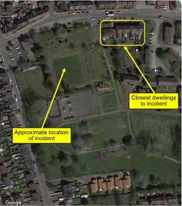
    Leaving aside the issue of compliance with the regulations, under the circumstances the pilot involved does need to be commended for filing the report. From an HF perspective there are perhaps two comments to be made. Firstly, it is worth remembering that young children do have a habit of doing something unexpected and normally at a critical moment. It sounds like they were not “involved persons” so irrespective of what the rules require, giving them a wide berth would have been recommended. To have briefed them and brought them into the fold as involved persons would have been even better still if the area had been suitable for flights under the A3 Open Category. They could have learnt from the watching the flights and being involved. The second comment is that however small the drone is, it can still physically harm someone. It is easy to think one as small as the DJI Mini Air2S is too small to harm anyone, but it isn’t. The main element in this report is simply to remember that the rules are there for a reason! A link to the CAA’s Drone and Model Aircraft Code can be found here: