Confidential Human Factors
Incident Reporting Programme

The Charity
Aviation
Maritime

The Charity
Aviation
Maritime
DUAS17

Initial Report
CHIRP Comment
The pilot in this occurrence initially used the location capabilities of Google to identify a business site as being accurate for the purpose of knowing whether it is inside or outside an FRZ. It is on the face of it a very easy assumption to make. We do not claim to know what Google’s verification processes are as far as the geospatial accuracy of what goes onto their maps is concerned, but there are clearly errors in some instances. If for instance they rely on data input by a business user using a postcode then this can cover a large area and show the map marker some distance away from its real location.
In previous issues of CHIRP we have explored the topic of the accuracy of geofencing and the depiction of FRZs and danger areas on a variety of Drone manufacturers’ onboard maps. Following discussions with the CAA we understand that this issue will be dealt with when C-marking rules are set out in due course.
The pilot in question does need to be congratulated for checking his location vis a vis the FRZ when on site. The fact that his colleague alerted him to the possibility of being in an FRZ is also good to see. Sharing information amongst pilots is important!
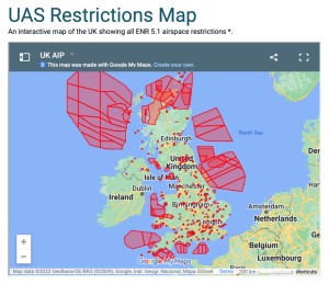
The final point that is worth making, is that if you are going to use Google for flight planning, then the start point is to access the NATS Aeronautical Information Service: https://www.nats.aero click ‘Airspace’ on the top menu and then select ‘Drones & new airspace users’ where you will find a tile that says ‘UAS Airspace Restriction Maps’ within which all current FRZs are overlain onto a Google map (see diagram) that can be downloaded if required.