Confidential Human Factors
Incident Reporting Programme

The Charity
Aviation
Maritime

The Charity
Aviation
Maritime
GA1369

Initial Report
CHIRP Comment
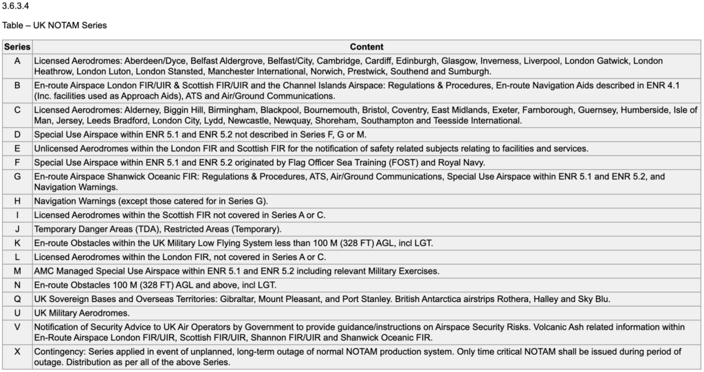
Ultimately, Class G airspace is a sharing environment in which neither military nor civil aviators have any priority over and above the Rules of the Air. We researched the NOTAMs mentioned and they were all ‘H’ series navigation warnings (which you just have to be aware of but don’t have to avoid) and not RA(T)s or TDAs (which you would have to avoid and would be ‘J’ series NOTAMs). Some useful links for understanding NOTAMs are the CAA Infringement Tutorial and UK AIP Gen 3.1 (Aeronautical Services) Table 3.6.3.4 which explains what each of the 18 NOTAM series types are (see below).
The specified locations of the 2 high-energy NOTAMs up to 20,000ft were applicable to operations at the reporter’s airfield, although [NOTAM 1] gave the blanket statement that associated military aircraft “…will avoid controlled airspace unless given permission to enter by appropriate ATSU” which implies that they would avoid the airfield ATZ. The reporter mentioned that their ATSU had tried to contact NATS to get further information but NATS would be unlikely to have any on a specific NOTAM and so that is probably why they received the response they did. In fact, the 2 high-energy NOTAMs had the same contact number within their Section E details where more information should have been available to the ATSU (our assumption was that this number gave access to the exercise controllers who would have details of when aircraft might be using the areas and at what heights).
All that being said, one wonders how much research into airspace usage is conducted before the decision is made to plan military low-flying exercises. Why these specific locations were chosen we don’t know, but we’re all well aware that there could be high-energy fast-jets flying at low-level without NOTAMs at any time in most parts of the UK Class G airspace and so at least these NOTAMs were a step up from that in warning that there will be a higher concentrations in the specified areas over the associated periods. We doubt that the military will consult with [Airfield] before deciding on their exercise areas and issuing the associated warning NOTAMs, and military crews will be well-versed in understanding that [Airfield] is there and to be avoided. But there is a valid argument that local airfields and their training areas could be taken into account during military exercise planning such that likely conflicts due to concentrated military activity might be reduced. Perhaps there is also a case for GA training airfields to publish their own favoured training locations (if such exist) so that this information is available to all – military and other civil aviators alike?