Do you read NOTAMS?
Contents
- Editorial
- Report to CHIRP!
- COMMENTS ON PREVIOUS EDITIONS AND REPORTS
- DUAS xx21 - Loss of control following geofence breach
- DUAS xx22 - Ageing batteries and what to look out for
- DUAS 0032 - NOTAMs and whether they get read
Don’t leave it to chance
Welcome to Drone FEEDBACK Edition 12.
I hope you have had a good summer’s drone flying, whether for pleasure or professionally. Statistics from the Regulator indicate that the number of flyers continues to increase, albeit perhaps at a lower rate than before. However, there are a growing number of drones in the air, and economically sustainable use-cases continue to be developed in the professional market. Diverse use-cases involve different aircraft variants that perform very different functions. All of them bring along different human/computer system interface risks to the party. Each of them have unique Human Factor related challenges. A couple of good examples are described in this edition!
Since Edition 11, there have as ever been some excellent new regulatory and technical innovations in the world of drones. These include announcements about the Atypical Air Environment; plans for implementation of SORA 2.5 in 2025; as well as a new subscriber-based digital flight approval service, which aims to reduce administration time for managing requests to landowners for take-off and landing requests. Airports adopting this include Aberdeen, Southampton, Cambridge and a combined Oxford Airport and Blenheim Palace. Encouraging though this may be, we continue to collect evidence of good old traditional Human Factors having as much influence on day-to-day flying and learning, as ever!
Let’s look at several recent examples and see what conclusions we can draw.
PS it can’t go without a mention that winter is of course approaching once more! Watch out for the HF consequences of lower temperatures, fog, snow and frozen fingers!
Rupert Dent
Drone / UAS Programme Manager
Report to CHIRP!
Our reporting process is simple and quick using either our website portal or our App (scan the appropriate QR code shown or search for ‘CHIRP Aviation’ – avoiding the birdsong apps that come up!). In our reporting portal you’ll be presented with a series of fields to complete, of which you fill in as much as you feel is relevant – not every field is mandatory, but the more information you can give us the better. Although you’ll need to enter your email address to get access to the portal so that we can screen out bots etc, none of your details are shared outside CHIRP, and we have our own independent secure database and IT systems to ensure confidentiality. That way you can help to improve safety by sharing important lessons without worrying about possible consequences. Anything that could identify a reporter is removed from our reports before progressing or publishing them, and we liaise with the reporter in every step of the process. Each report plays its part in raising awareness of important safety issues and wider trends and provides lessons for all to learn from. Report-by-report we can make aviation safer – as our strapline says, “you report it, we help sort it.”

COMMENTS ON PREVIOUS EDITIONS AND REPORTS
We always welcome readers’ comments on what we produce. Whilst we try and keep an eye on social media sites, it is not always possible to keep track of the multitude of Drone-related sites and what is being discussed. Do therefore feel you can email us directly at: mail@chirp.co.uk with your Human Factors or Just Culture related comments on the reports we write about.

Pooleys have kindly agreed to support CHIRP’s fund-raising activities by allocating us a discount code on their website shop. Enter the code ‘Chirp’ (case sensitive) at the appropriate point at the payment stage to get 5% discount and generate some commission for CHIRP. Sadly, this doesn’t apply to the purchase of Bose headsets, but everything else qualifies! If you do use Pooleys for your purchases, or know other people who do, please do share the code. The more the code is circulated, the more it is used and the greater the commission generated to help CHIRP build its resources to do more. https://www.pooleys.com

An Operator’s take on Safety:
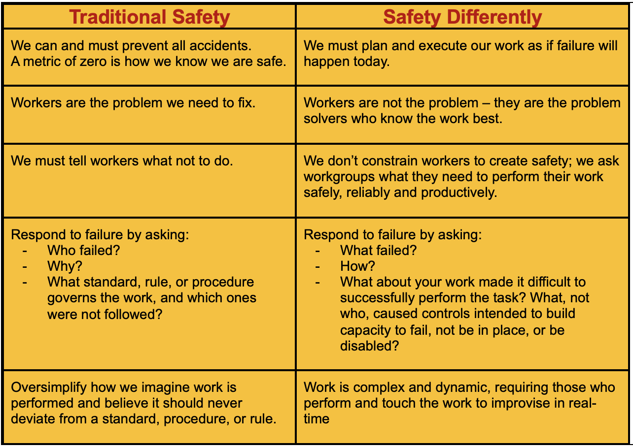
The following set of principles aimed at helping pre-empt Human Factors in an Uncrewed Operation were kindly sent to us by a large operator we know. We liked them and thought that other operators might be interested to see them.
Some Principles: we cannot avoid all Incidents
Reports
DUAS xx21 - Loss of control following geofence breach
Initial Report
AAIB Report 29335 published October 2024. Whilst being operated in a manual flight mode, the unmanned aircraft breached the geofence and changed to an automated flight mode. In response, the remote pilot reduced the throttle and changed back to the manual mode. Control of the aircraft was lost because the mode was changed at a low throttle setting and the subsequent actions to regain control were unsuccessful. The aircraft struck the ground and was destroyed.
The operator no longer uses the manual mode and has promoted the use of standardised phraseology between the ground control station operator and the remote pilot. Further action has been taken to consider and apply a suitably sized geofence for each operational flight.
The Operation Safety Case on which the Civil Aviation Authority (CAA) granted a Specific Category Operational Authorisation was missing definitions and procedures for the use of geofences and actions to be taken in the event of a breach. A Safety Recommendation has been made to the CAA as these omissions have further effect, as the use of a geofence is widely used as a mitigation for several other operational risks.
The Remote Pilot (RP) was undertaking a skills currency flight using a Malloy Aeronautics T150 unmanned aircraft and was assisted by a Ground Control Station (GCS) operator. The RP and GCS operator were in two-way communication via radio. The RP was flying circuits in Stabilised flight mode (stab mode) at a training ground. It is a remote site on farmland used by the organisation he was contracted to fly with, as an R&D and training pilot. The geofence for the flight was 40m high by 300m radius with the centre on the take-off point (see picture). The dimensions of the geofence were not considered by the RP and GCS operator prior to the flight but accepted as a standard training envelope.
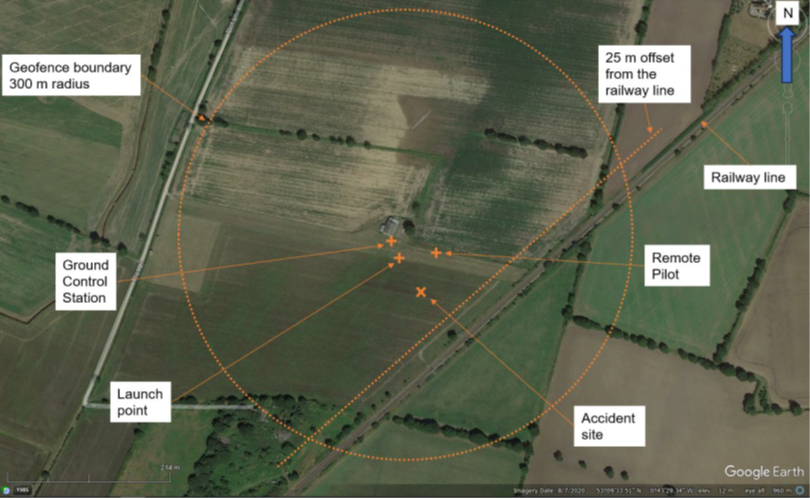
The GCS operator noticed the aircraft was approaching the upper limit of the flight geography zone within the geofence and he informed the RP using terminology not immediately understood by the RP. The RP was aware that the aircraft was turning to the right and climbing quicker than he had expected. Shortly afterwards the aircraft breached the upper limit of the geofence and reverted to an automated Return to Launch (RTL) flight mode. The RTL automation initially commanded the aircraft to climb, which the RP instinctively counteracted by reducing the throttle. The GCS operator informed him that RTL mode was engaged, and the RP changed the flight mode, by cycling the three-way flight mode selector switch on the handheld transmitter, to loiter and then back to stab mode.
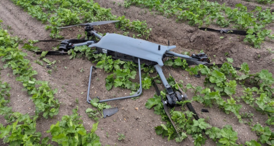
The aircraft diverged from level flight and was seen to follow an erratic flight path unfamiliar to the RP, during which it achieved a maximum pitch of -41° and -60.9° of roll. To regain control the RP increased the throttle to 100%, which caused the aircraft to overcorrect, and it then pitched to 85.3° with 60° of roll before descending rapidly from a height of 37 m. The RP realised he could not regain control and switched to an automated mode (loiter mode) but by this time the aircraft was heading towards the RP’s ground position, and he decided to close the throttle, bringing it to the ground. Twelve seconds had passed from the geofence breach before the aircraft struck the ground approximately 50m from the RP’s position and within the horizontal boundary of the geofence.
CHIRP Comment
There are a number of points worth highlighting from this report. This isn’t the first occurrence where communication between the RP and the GCS has perhaps been one of the Human Factors that caused an accident. It seems that the initial communication between them resulted in an element of confusion. Perhaps adopting the use of more familiar crewed aviation terminology might have made communication easier?
Fairly quickly afterwards, the RP’s understanding of what the aircraft would do after they toggled the mode switch then exaserbated the problem. If the pilot had known that switching to Loiter and then Stab modes was going to result in the effect that it did, there is no doubt they would not have done it. Perhaps the Operator should have put more emphasis on ground school/training as well as familiarisation on type. One wonders whether or not latency in the controls was what then led to the final sequence before it impacted the ground.
Geocaging is going to become more important in the future, given the role it will play in Specific Operations such as Atypical Air Environment and BVLOS with Visual Mitigations. Fully understanding what the aircraft will do if it gets close to the cage limts will be an essential part of training. Also, checking the geocage setting should have been part of the pre-flight checks, along with making sure the alerts weren’t inhibited. For the same reasons as mentioned above, the detail described in Volume 2 of the Ops Manual should cover all of the possible iterations of touching the edges of the cage, so pilots can be familiar with what the automated actions of the aircraft will be, if it does touch the edge of the cage.
Finally, choosing an environment a little further from a railway track for training exercises would have probably been a wise move. The aircraft might have landed on a train which, incidentally, could have been well inside the cage! Even if the line marked as 25m from the railway track was part of the OSC, setting the geofence as a 300m radius from the take off spot seems to be inconsistent with what their approvals allowed.
DUAS xx22 - Ageing batteries and what to look out for
Initial Report
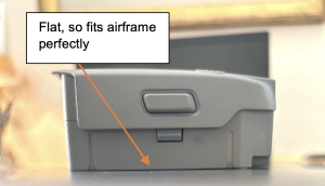
AAIB Report 29860 published September 2024. The UA lost power whilst being flown in an area that excluded the public. This was likely due to the battery becoming detached in flight and it is possible that the battery was not fully latched in place. The same model of battery has been known to swell when it starts to deteriorate, which can compromise its secure retention within the UA. Such swelling can be detected before flight by checking that the battery can sit firmly on a flat surface without rocking, and the operator has highlighted the need for such a check to its pilots.
The flight was the fourth deployment of the UA and was conducted at night in the early hours. The pilot had completed their task and had positioned the UA for the descent when it appeared to lose power and then fell to the ground. The downloaded data abruptly stopped whilst the UA was in the air. Prior to the data loss, the recorded battery health and level of charge were sufficient for continued flight. The battery and UA came to rest some distance apart with the battery still indicating it was powered. The pilot believed they had installed the battery properly but could not be certain.
Both the battery and the UA suffered physical damage, but examination of the plastic battery latching mechanism on both items showed no signs of damage. This lack of damage could indicate that separation did not occur as a result of the impact with the ground.
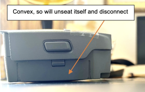
An online search found examples where the same model of battery pack had swelled, and this had compromised the ability of the battery to be securely attached to the UA. An examination of the battery pack after the accident showed that the casing was split, probably as a result of the impact with the ground, but also that there was some evidence of swelling. However, it was not possible to determine whether this swelling was present prior to the accident. If a battery was swollen and had a curved underside surface, this can impede or prevent secure retention of the battery by the latching mechanism.
Following this accident, the UAS operator advised all its pilots of the following:
‘The initial assessment is that the battery either was swollen and or the battery hadn’t completely engaged in the locking mechanism during the build phase. The battery then disconnected and parted with the aircraft when the pilot commenced the landing phase.
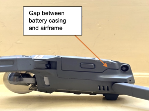
Please be reminded that with any drone, prior to flight, the battery is checked, and you confirm this with a confidence test. (Push pull) and that you photograph or BWV [Body Worn Video] the completed build. Not only from the top but of any locking part and the side view. This should be completed each time you change a battery. NB – Although the locking buttons on the side of the battery should be protruding to indicate locked, as per the photos below if the battery is not sitting flush then even though the buttons are protruding, the battery is not secure.
Below is a photo of what we think happened. Which from looking down on the drone or at night could be missed if rushed.’
This message to its pilots was accompanied by an instruction to report any battery issues to the appropriate person to arrange replacement. The 3 pictures show: the battery not properly secured, but with button positions that could indicate it was if viewed from above; a normal battery with a flat underside; and a battery with evident swelling.
CHIRP Comment
For those readers that have a year or two under their belt flying drones, batteries are a great deal better than they used to be but swelling as they get older has always been something of a potential hazard. If they begin to swell and are then used to fly enthusiastically, they get hot and swell even more. The DJI Mavic 2 batteries have a developing reputation for swelling as they age. If swelling occurs, the battery disconnects itself from the airframe in flight and the motors stop, with the inevitable happening shortly thereafter.
A useful indicator of battery health decreasing, with the potential for swelling to increase, is that flight times start to deteriorate in conditions that are otherwise the same. It’s also worth noting that as the Outside Air Temperature increases, the chance of a battery swelling increases with it, even if it remains within the operating temperature limits set out in the specification. CHIRP’s recommendation is to immediately dispose of any batteries that have begun to swell, and avoid the temptation to tie-wrap, Velcro or tape the batteries onto the airframe. The CHIRP Board discussed at some length whether a recommendation should be made to manufacturers to review the material that batteries are made from and how they lock into place when fitted to an aircraft; we understand that the AAIB has been in touch with DJI regarding this matter but has so far received no response
For those operators who work extensively at night when lighting of the site could be limited, a 3D printed frame that can be passed over the battery to check its shape is perhaps a useful way of verifying whether there is any swelling, and this could be introduced into the pre-flight checks sequence.
Another suggestion is for operators such as emergency services who require instant deployment capability from their equipment, consider having two separate sets of batteries to ensure one set is being deep cycled whilst the other set is always available and ready to go. Keeping batteries fully charged and not deep cycling them often enough will, in the end, accelerate swelling. In addition to this, setting the battery discharge timing in the maintenance App that is being used so that it coincides with shift patterns, might also help with managing deep discharge cycles and readiness. Also, CHIRP recommends that batteries are not stored at full charge, but rather at the manufacturer’s recommended charge levels. Whilst some batteries now have integrated automatic discharge software, some of the earlier aircraft and batteries do not have this capability and so the user should discharge the battery to the correct level, for storage.
Finally, we would strongly suggest that an operator needs to include an aircraft retirement review procedure in its operations manuals. As technology advances there will come a moment when retiring an aircraft will be both appropriate and necessary. Incorporating this into the business plan at the outset will help deal with the issue from a financial perspective.
DUAS 0032 - NOTAMs and whether they get read
Initial Report
I completed an RPAS Notification form stating flight date, time and geo-location. I have completed these dozens of times for our quarry locations. This information was sent to [the Military Air Movements Cell (MAMC)] at SWK-MAMCLFCOORD@mod.gov.uk. On the email, I also add my phone number and the times it will be answered or leave a message. In addition, I also filled out a report of the drone flight on Altitude Angel.
I was flying the drone (a Sensefly eBee X – fixed wing), which is flown automatically by GNSS control through the calculated waypoints using eMotion 3. I was about to conduct my second flight over the southern end of the quarry and was setup on the western tip, which provides a 360degree view for over one kilometre in any direction. When I fly, I always have my second phone open on Flight Radar. I had the laptop open, the drone powered and was designing the flight for upload when I heard an aeroplane to my west. I looked in that direction and saw a black, fast-moving low-level prop engine plane. I watched it and worked out it was approximately one kilometre to my west; I watched it travel south to north.
I looked at Flight Radar, clicked on the plane icon and then saw it was RAF Texan flying low and fast. As it reached the end of this leg it turned west (further away) from the quarry. I then noticed a second icon on the screen and waited for this one to fly past as it was on the same trajectory as the first one. I decided to wait and removed the battery from the drone. As the second RAF Texan completed the south to north trajectory it turned east and then south. It flew south directly over the quarry along its long north south axis. I watched it fly to my east by approximately 150-200m and approximately 25m above my head.
I am concerned that this happened because I had filled out the Military Notification of RPAS Activity. I have had several phone calls from pilots asking me to not fly when they are close or passing over the quarries after I have completed the form. I always consent to their request – the GVC course showed the aftereffects of a bird strike on a military helicopter.
After the flight I checked the RPAS Activity form was filled in correctly and had been sent, it was on both accounts. Possible external factors to consider were: a) the information I sent was not entered into the RPAS Activity dataset; b) the information was entered but too late to affect the flight; or c) the data was entered but not acted upon by the pilot(s). I did not receive a message stating the information was in the system or a phone call from a pilot.
Recent addition from the reporter: just a note, since the overfly of the quarry by the RAF Texan aircraft, I have notified the Military of several flights I have since conducted at our other quarries. On each occasion I have had a confirmation reply that my notification of a drone flight has gone onto their system.
Lessons learned: Always use what is available – Flight Radar in this case; if something is close by – wait and only fly when the aircraft has moved away; never rely on forms, even though this is the primary source of information.
RAF Safety Centre Comments
A civilian drone operator reported that they flew their fixed wing drone at a pre-planned location, a quarry in Devon. Ahead of conducting their second flight of the day, they report that they observed a “black fast moving low level propellor engine aeroplane” fly overhead their planned operating location at approximately 25m (~82ft) AGL, which concerned them as they had submitted a Military Notification of RPAS Activity the day prior to their intended flights. They believed the aircraft to be an RAF-operated Texan.
During investigation of this report, the following was concluded:
Military Notification of RPAS Activity. Interrogation of the military deconfliction tool shows that the drone operator did submit a notification to the Low Flying Booking Cell. This notification was displayed on the deconfliction tool.
- Texan Ops. Contact with the Texan operating squadron confirms that they did have aircraft operating in this location at that time, conducting a pairs land away sortie [a 2 aircraft mission with a student flying one of the aircraft]. After discussion with the pilot of the aircraft believed to have overflown the drone operator’s location, they outlined their usual actions when an RPAS notification presents in the planning phase. Further interrogation of the deconfliction tool shows that the Texan pair’s planned low-level route would keep them laterally displaced from the RPAS notification.
- Texan Height. Contact with the operating squadron confirmed that their routine MSD [Minimum Separation Distance from the ground] is 250ft, and that it is highly likely that the drone operator’s estimation of 25m (~82ft) AGL is incorrect. Dependant on the drone operator’s exact location, it is estimated the aircraft would have been at approximately 400-500ft.
Through discussion with members of the operating squadron, including the pilot of the aircraft believed to have overflown the drone operator’s location, they confirmed that the Military Notifications of RPAS Activity inputted to the deconfliction tool are factored into planning for Texan Ops. These notifications are routinely presented during the planning phase and crews will attempt to deconflict through time by contacting the drone operator in advance. If contact is not achieved, they will deconflict through lateral and/or vertical separation. If any off-route flying is conducted, which is often the case given the training demands of military aircraft, the notifications will be treated the same as a NOTAM and subsequent action taken to avoid laterally/vertically.
Further discussion with members of the operating squadron revealed that whilst the Military Notifications of RPAS Activity are greatly appreciated by crews as a barrier to prevent mid-air collision with a drone, they do come with certain limitations. This is due to the following commonly observed factors:
- Drone operators will often not answer their listed contact numbers, despite numerous attempts to call by crews.
- Drone operators’ intended operating locations often differ from those displayed on the deconfliction tool when contact with them is established.
- Drone operators’ intended operating times often differ from those displayed on the deconfliction tool when contact with them is established.
After a review of the occurrence findings, we offer the following observations:
- The current method of notification for drone operations is a useful barrier in the prevention of midair collision and we would strongly encourage drone operators to continue this good practice. The perceived weaknesses in the system, highlighted above, should be shared in order to educate and increase awareness which should improve the utility of this process for both aviators and drone operators. It is important to note that a notification like this will not warrant an avoid for our military crews but is extremely valuable in providing enhanced situational awareness.
- Due to the fast-paced and involved nature of pre-flight briefing, it may not always be possible for the crew to contact the drone operator prior to flight. The system is not 100% effective and is certainly no guarantee that deconfliction will be achieved; for example, a crew may have already taken off when a late-notice drone flight is notified, or a take-off time is delayed which then brings a conflict that previously didn’t affect into play. Weather and other operational elements experienced inflight may also cause a military flight to deviate from their originally planned routing.
- See and avoid remains the primary barrier to mid-air collision with a drone, but due to the small size of the majority of drones and the nature of the fast, low-level flying that the military conduct, the military pilots are reliant on drone operators enacting this mitigation barrier and landing their drone (or manoeuvring to a safe position) on seeing or hearing an approaching aircraft. This is in-line with the CAA published Drone and Model Aircraft Code – this code of conduct should continue to be highlighted to operators to ensure that they are following best practice and flying safely and legally.
We absolutely applaud the approach of the drone operator involved in this incident and their proactive actions to preserve air safety. Please continue to notify and report as this is the most effective way of increasing our situational awareness. I would again promote the promotion and use of the CAA Drone and Model Aircraft Code to ensure safe and legal operating. The military continues to educate our crews on this particular risk and, with more and more drones taking to the skies, we will continue to develop our procedures to ensure the best protection for our crews.
CHIRP Comment
There are some great learnings from both the reporter and the response from the RAF. We understand that the Texan aircraft had had to conduct a formation navigation turn in the area and these manoeuvres are demanding on students. As a result, it is therefore likely that student pilot may have become task focussed on the turn at the expense of the drone notification, albeit flying over the area at 4-500ft according to the RAF investigation. Judging the height of aircraft above the ground is notoriously difficult to do and so, although we do not question the drone operator’s assessment, we cannot make any comment on what the actual height of the Texan was. One thing to note however is that the altitude shown on FlightRadar24 will be based on transponder altitude of 1013hPa, and so will bear little resemblance to the actual aircraft altitude (unless of course the actual QNH happened to be 1013hPA) and corresponding height above the ground.
The topic of notification of drone flights and NOTAMs is currently a matter of some discussion. The one thing that is certain is it is important to read NOTAMs and other notification information when planning a flight, irrespective of whether the flight is crewed or uncrewed. On this occasion it was opportune that the drone wasn’t flying when the Texan flew over the quarry but, had it been flying, there is every chance that the drone pilot would have felt the obligation to land. This might then have resulted in them re-flying the whole site again to capture a complete data set.
There is a reliance on the drone pilot to avoid crewed aviation or, if it is necessary, to land. Although this is not specifically within SERA.3210 ‘Right-of-way’(c)(2) as one of the a priorities for converging aircraft, because the small size of a drone makes it much more difficult for a crewed aviation pilot to see it, best practice means it is incumbent on the drone pilot to move out of the way or preferably land should there be a potential for conflict. SERA.3205 ‘Proximity’ states that: “An aircraft shall not be operated in such proximity to other aircraft as to create a collision hazard”, which mandates the overarching requirement for all aviators to avoid collisions.
It is worth emphasising that just because a pilot has issued a NOTAM, it does not automatically give them a right of way or an assumption that their notified airspace will be avoided. H-series NOTAMs are warnings only, not restricted airspace (albeit it’s always sensible to avoid a NOTAM area whenever feasible). This applies both to crewed and uncrewed aircraft flight crew. Drone pilots will build confidence in the crewed-aviation community if they give accurate position and timing details of their flights in NOTAMS and aim to stick to them. Also, when completing a NOTAM, a pilot is well advised to enter their observer’s mobile number as the point of contact on the day, rather than an office telephone number. This enables other pilots to contact them directly to discuss how to best avoid potential airborne conflicts. Based on experience, CHIRP would recommend the pilot filing the NOTAM also verifies the correct point of contact, including the telephone number, in the subsequent NOTAM because ACOMS have been known to transpose telephone numbers incorrectly in the past.
For clarity, it is worth emphasising that approximately 90% of drone activity in unsegregated airspace does not involve drones flying from A to B, but rather drones performing data capture activities in a volume of airspace that is often delineated as a bubble and that tends not to be linear. It should be noted that when a Drone Operator or a Model aircraft site informs the military, via the Military Airspace Management Cell (MAMC), of planned activity, it does not automatically generate a NOTAM. It only generates a NOTAM if the activity is exceptional e.g. above 400ft etc. There are occasions when issuing a NOTAM for a Drone flight under 400ft would enhance safety. An application to do this in the past has resulted in a refusal by the NOTAM office and this may be worth reviewing.
Another suggestion made by the CHIRP Board is that it is important to check NOTAMS and the AIP, so that permanently notified sites that are listed in the AIP are picked up, as well as any sites that are temporarily listed in the AIP via the use of a NOTAM. The UK Airprox Board has separately recommended to the military that Model Flying sites for aircraft over 7.5kg should be marked on their VFR charts. The recommendation is currently being implemented in appropriate areas.
Finally, it should be noted that if a Drone Operator is flying in an FRZ, it is the responsibility of the Aerodrome that controls the FRZ to submit a NOTAM, not the Drone pilot.

