An independent and confidential
reporting system for the Aviation industry

Short Notice Temporary Danger Areas “TDA’s”
Contents
- Editorial
- I Learned About Human Factors From That (ILAHFFT)
- Report to CHIRP!
- Comments on previous editions and reports
- Get 5% discount at Pooleys Flight Equipment through CHIRP
- Acronyms Table
- DUAS XX30 - AAIB Bulletin: 10/2025 PW Orca AAIB-30757
- DUAS 0036 - Inadvertant BVLOS
- DUAS 0037 - DJI Mini 5 Flyaway
- DUAS 0038 - A Short Notice TDA

Rupert Dent
RPAS Programme Manager
Welcome to Drone FEEDBACK Edition 15.
First things first, at the time of writing, Altitude Angel, an important part of the drone ecosystem, has gone into administration and drone operators will be the poorer for it. In practical terms, it means that, amongst other services provided by Altitude Angel, the accuracy and future of the very useful app Drone Assist is now unclear. In the past, it has played an increasingly useful role in making flight planning for drone pilots easier and quicker. Many operators were voluntarily using it as an unofficial way of posting details of their planned flights for the purpose of deconfliction. Airports were also starting to use Altitude Angel Services to help them managetheir local airspace. We hope a solution is found to continue its availability.
As we all know, drone technology is evolving very quickly and for civilian operations, regulations are trying to keep up. In this editorial, I wanted to address something that has happened recently that may increase the risk of human-factors-based occurrences, at least until Uncrewed Traffic Management and Detect and Avoid technology becomes available. Some providers of first responder services have decided—quite rightly—that drones can be very useful in recording visual information. The earlier a drone is dispatched to the scene of an incident, the more complete the information it will be able to record. However, to do this effectively they need to fly BVLOS and at an instant’s notice from wherever their nearest drone is based. It is clear they will not know in advance where they are going to fly and there is currently no mechanism to pre-warn other air users of the intended flight. Detect and Avoid technology is immature and not yet approved and an Uncrewed Traffic Management capability does not yet exist.
As a result, the CAA, in complying with its legal obligations, has decided to impose a Temporary Danger Area around the site of where an Emergency Responder is intending to base a Drone in a Box (DIAB) operation. Numerous sites have been identified as potential locations where a DIAB would be beneficial. Even if they are regarded as State Flights, a request to penetrate the area, along with some form of deconfliction with other crewed or uncrewed flights in the same TDA, must be regarded as essential.
We feel that, as a minimum, publishing contact details to be used by those requiring access to any of these sites would be very helpful, along with details of how deconfliction will work in practice. It would also be useful, for instance, if there was some clarity on whether approval to enter the TDA can be granted by the First Responder or by the CAA. This will reduce the chance of pilots not being aware of a very last-minute NOTAM being published imposing a TDA, or indeed a TDA being imposed when a flight is already underway, which then leads to what will essentially be a human-factors-related occurrence. As a final point, it is also worth mentioning that GPS jamming is increasingly being used to reinforce a TDA. New Year celebrations in central London saw three separate TDAs being imposed, including one for GPS jamming, all of which intersected.
Stay safe,
Rupert Dent
Drone / UAS Programme Manager
P.S. A recent press announcement from Indra Group confirms they have bought Guardian UTM from Altitude Angel.
Recognition and changes at CHIRP
Thank you to Nicky Smith for her contribution to CHIRP over the past 12 months. As Director Aviation, Nicky played an important role in strengthening CHIRP’s work across the aviation programmes, including Drone/RPAS and in supporting the organisation’s objective of enhancing aviation safety through an independent, confidential reporting system. Nicky’s commitment and support have been greatly valued and we thank her for all she has contributed during her time with CHIRP.
I Learned About Human Factors From That (ILAHFFT)

Report to CHIRP!
Our reporting process is simple and quick using either our website portal or our App (scan the appropriate QR code shown below or search for ‘CHIRP Aviation’ – avoiding the birdsong apps that come up!). In our reporting portal you’ll be presented with a series of fields to complete. Fill in as much as you feel is relevant – not every field is mandatory, but the more information you can give us the better. Although you’ll need to enter your email address to get access to the portal so that we can screen out bots etc, none of your details are shared outside CHIRP, and we have our own independent secure database and IT systems to ensure confidentiality. That way you can help to improve safety by sharing important lessons without worrying about possible consequences. Anything that could identify a reporter is removed from our reports before progressing or publishing them, and we liaise with the reporter in every step of the process. Each report plays its part in raising awareness of important safety issues and wider trends and provides lessons for all to learn from. Report-by-report we can make aviation safer – as our strapline says,
“you report it, we help sort it.”

Comments on previous editions and reports
We always welcome readers’ comments on what we produce. Whilst we try and keep an eye on social media sites, it is not always possible to keep track of the multitude of Drone-related sites and what is being discussed. Do therefore feel you can email us directly with your Human Factors or Just Culture related comments on the reports we write about at mail@chirp.co.uk
Get 5% discount at Pooleys Flight Equipment through CHIRP
Pooleys have kindly agreed to support CHIRP’s fund-raising activities by allocating us a discount code on their website shop. Enter the code ‘Chirp’ (case sensitive) at the appropriate point at the payment stage to get 5% discount and generate some commission for CHIRP. Sadly, this doesn’t apply to the purchase of Bose headsets, but everything else qualifies! If you do use Pooleys for your purchases, or know other people who do, please do share the code. The more the code is circulated, the more it is used and the greater the commission generated to help CHIRP build its resources to do more.
![]()
Acronyms Table
Reports
DUAS XX30 - AAIB Bulletin: 10/2025 PW Orca AAIB-30757
Initial Report
Note: this originated from AAIB report no 30757
Type of report: Accident
Aircraft Type and Registration: Phoenix Wings Orca
No & Type of Engines: 8 electric motors
Year of Manufacture: 2024 (Serial no: PW54)
Date & Time (UTC): 25 March 2025 at 1450 hrs
Location: Coombe Country Park, Warwickshire
Type of Flight: Commercial Operations (UAS)
Persons on Board: Crew – None; Passengers – None
Injuries: Crew – N/A Passengers – N/A
Nature of Damage: Damaged beyond economic repair
Commander’s Licence: Other
Commander’s Age: 23 years
Commander’s Flying Experience: 85 hours (of which 5 were on type)
Last 90 days – 16 hours
Last 28 days – 7 hours
Information Source: Aircraft Accident Report Form submitted by the Pilot.
Synopsis
The aircraft struck the ground in a wooded area whilst on approach to land at a site adjacent to Coventry Hospital. The accident occurred during the sixth consecutive flight, which was in preparation for demonstrating the aircraft being operated in accordance with the operator’s Beyond Visual Line of Sight with Visual Mitigations (BVLOS VM) authorisation. The cause of the accident was identified as a software bug in combination with a loss of synchronisation between the Remote Pilot (RP) and the Safety Remote Pilot (SRP), whereby the SRP’s hand controller had remained set to the disarm position when the aircraft had taken off. When the aircraft came within range of the SRP’s controller, this resulted in power being removed from the aircraft’s electric propulsion motors, leading to the aircraft stalling, its emergency parachute system being disabled, and subsequent uncontrolled descent from a height of 60m.
History of the flight
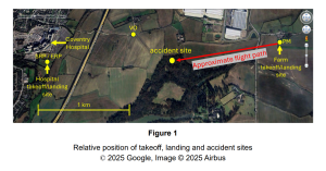
Several flights were being flown a total distance of about 1.5nm between a farm and a field adjacent to Coventry Hospital (Figure 1). These were being performed in preparation for a BVLOS VM demonstration flight.
The flight crew consisted of a Remote Pilot (RP), Safety Remote Pilot (SRP), Pad Manager (PM), Visual Observer (VO)¹ and an Emergency Response Team (ERP). The PM was located at the farm site and had a handheld controller that allowed the aircraft to take off and land. The SRP was at the hospital landing site and had a remote controller that provided the ability to take manual flight control of the aircraft, arm and disarm it and also terminate flight in the event of an emergency (refer to the aircraft information section for further detail). The RP was at the operator’s facility some miles away and was using a PC-based ground control station to control the aircraft, with the VO located about midway between the two sites and the ERP collocated with the SRP (Figure 1).
Coordination between the flight crew was made using two-way radios, with the control settings of the RP and SRP controllers being manually synchronised by each pilot, so that the aircraft was appropriately armed in preparation for flight and disarmed (shutdown) after each landing.
Five flights were successfully flown over the period of about an hour and, having completed the ground checks at the farm site, the aircraft took off to fly back to the hospital landing site. The aircraft climbed vertically to a height of about 50m AGL before transitioning to forward flight where it then climbed to its cruise height of 60m AGL. The aircraft’s take-off weight was 38.9kg.
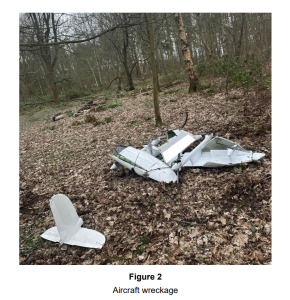
The aircraft was observed to follow the planned flight profile but as it approached approximately the halfway point the aircraft’s motors suddenly stopped. The aircraft initially maintained altitude but subsequently stalled, before descending quickly and striking the ground within a wooded area (Figure 2). No persons were injured and there was no damage to property; the aircraft was damaged beyond repair.
The RP, SRP and PM reported that they had not made any selections on their respective controllers in the period before the aircraft departed from controlled flight.
Footnote
¹ The VO is a designated person who assists the pilot during BVLOS flights. The VO’s primary responsibility is to maintain visual contact with the aircraft and its surroundings, alerting the remote pilot who may not be able to observe the aircraft to any potential hazards or conflicts. The VO provides the visual mitigations required by the BVLOS VM authorisation.
Accident site
The aircraft struck the ground in a wooded area (Figure 2) which was accessible to the public. Approximately 250m from the accident site was an outdoor activity centre.
Analysis
When the aircraft took off from the hospital site during the fifth flight, the SRP controller’s arm/disarm switch was in the arm position. In accordance with the operator’s procedures it should then have been set to the disarm position when the aircraft landed and set back to the arm position prior to take-off. However, the recorded data showed that as the aircraft approached the hospital landing site, and communication with the SRP controller was established, the controller was recorded as being in the disarm position. The SRP reported that he had not moved this switch during the flight. It is therefore most likely that the selection was synchronised correctly with the RP after the aircraft had landed at the farm, but a loss of synchronisation with the RP then occurred, with the selection remaining in the disarm position when the aircraft took off.
The checklist used by the RP and SRP did not include a formal verification (check and challenge) of the arm/disarm switch selection. This increased the possibility that a loss of synchronisation between the two remote pilots was not detected and this risk may have been further increased by conducting several flights in relatively quick succession.
CHIRP Comment
CHIRP Comment:
- This is an excellent report on the hazards of a complex operation using several pilots with different controllers and handing over control between different handsets.
- During pre-flight checks, verifying the settings on each controller are compatible and aligned, is critical to successfully completing flights of this nature.
- If using a controller with toggle switches that can easily be knocked, the settings check should be performed just before taking control.
- There should be a clear verbal check and challenge protocol between the pilots, when handing over control.
- As BVLOS (VM) flights become more frequent, passing control from one pilot and controller to another, positioned further along a linear route, means that the potential for the type of Human Factors error discussed in this report, could become more likely.
- Training for every aspect of controller handover needs to follow a detailed protocol and be practised regularly.
- OEM training on its own may be insufficient and should be supplemented with Operator centric training, based on relevant experience.
- The OEM might want to consider additional non regression testing of the UAS software, to improve the quality of its products. The fact that the parachute could be disarmed at the same time as power was removed from the motors, is a false coding logic that should have been found during quality control.
DUAS 0036 - Inadvertant BVLOS
Initial Report
During a pre-programmed autonomous flight, the UAS went behind a hedge of tall trees that the remote pilot thought would be low enough to ensure VLOS for the flight height (100m).
CHIRP Comment
The Board had the following comments:
- When planning autonomous flights, it is difficult to predict the height at which the aircraft will stay in line of sight of the pilot, particularly if the mission includes a controller handover. To avoid brief moments, like in this report, when an aircraft is obscured during its flight by a tree or a building that is in front of it, always add a few meters to the planned height of the operation if you are in doubt.
- If it is a particularly complex location, fly the planned route manually first to check that it remains in Visual and Radio Line of Sight, note the height and other route details before loading the correct parameters into the autonomous flight software accordingly.
- It is important to always include in the pre-flight checks the setting for what the aircraft is programmed to do, if it loses the C2 link. If there is a momentary disconnect, it is vital that the pilot is not then surprised by what the aircraft does.
- If you are planning a mapping mission and it looks as if the aircraft is going to go behind an object, don’t forget that you have the option of pressing pause which will then give the pilot an opportunity to change their position to retain line of sight.
- Always remember that the drone controller often shows the height of the aircraft above its take off point, rather than above the ground it is flying over or sea level.
DUAS 0037 - DJI Mini 5 Flyaway
Initial Report
“Flying near The Angel of the North my DJI Mini Pro 5 suffered a transmission malfunction and was lost.
We believe it was a flyaway and probably safely landed somewhere once the battery began to die.
Last known coordinates were 54.913728, -1.5891143 but this was simply where the transmission failure occurred.”
In dialogue with the reporter, we understand that the manufacturer has said they are unable to say whether it was pilot error or their aircraft that was at fault, even after looking at the CSV files, which record multiple parameters at millisecond intervals. The last line of the CSV file reads “No image transmission signal. Aircraft not connected to RC. N/A Image transmission signal lost (Code: 80001)”.
CHIRP Comment
The Board had the following comments:
- Although, on the face of it, this may not be a Human Factors related occurrence, it is odd that the manufacturer is unable to find a technical reason for the flyaway. There is a chance that HF might have had something to do with the occurrence.
- The Angel of the North site is not in controlled airspace or marked in any way as being a risk.
- If GPS jamming had been deployed, it should have been notified via the publication of a NOTAM.
- Depending on the position of the pilot with the controller relative to the aircraft, it is possible that the signal between the two disconnected because it couldn’t go through the large metal wings of the sculpture.
- The DJI Mini 5 is a very recent product. If there was a manufacturing related issue, it may get dealt with in a software update that would be issued a few months after the drone had become available. DJI have a track record of doing this.
- If the drone did not have time to get a GPS loc on start up, it is possible that its RTH functionality did not work properly.
DUAS 0038 - A Short Notice TDA
Initial Report
We had planned to do a Drone survey in Berwick (Class G airspace) and had notified our intention to do so via the APP “Drone Assist” several days in advance. Having checked NOTAMS on arrival at site around 08.00am (there were none relevant to the site we were at) before flying a survey, we undertook an initial flight with a Mavic 3 Enterprise RTK for the purpose of verifying a number of requirements including the level of the tide, distances, the length of shadows etc. Once we had finished the flight, we started preparing for a sequence of autonomous flights to collect the specified point cloud data, using a DJI M300. Just prior to taking off we again checked NOTAMS and somewhat to our surprise noticed a NOTAM that had activated with immediate effect a Temporary Danger Area covering the site where we were located. Fortunately, there was a contact number that we could call. This is not always the case. On calling the number, we discovered that the TDA had been activated with immediate effect by the Coastguard, who were dealing with a callout. We were told that they were not authorised to give us permission to enter the TDA, but they would call us back to let us know when they had asked for the TDA to be closed down. We received a call approximately 40 minutes later telling us that they had completed their mission in the area and had asked for the TDA to be closed. It then took a further two hours for the request to deactivate the TDA and for this to be evidenced via a NOTAM appearing visually on Drone Assist. The Coastguard was not aware of the APP and had not been aware of our presence at that site.
CHIRP Comment
The Board had the following comments:
- Checking NOTAMS before every single flight rather than every single day, is clearly now an absolute requirement.
- If a TDA is imposed during a flight and at very short notice, the only current way of finding out about it is looking at NOTAMS on the AIS. Using Drone Assist is no longer advisable, because it may not now be accurate, following the Administration of Altitude Angel.
- Substitutes to Drone Assist may appear in due course, so it is worth keeping an eye out in social media for any references to them being announced.
- Drone pilots may want to telephone the London Flight Information Service “FIS” or Scottish FIS, who will always have up-to-date information in their respective regions.
- Longer term we expect there to be changes to the way NOTAMS are promulgated, but we do not know the timing.
- The Board noted that there will be financial and duty time implications for a Drone Operator, if a TDA is imposed at short notice, particularly if it then takes several hours to close it down.
- Just because there is a short notice TDA in place it may get missed by the Drone community who are unable to have a live AIS feed on their controller, so crewed aviation needs to bear in mind they should continue to keep a good lookout.
- For up-to-date information on specific NOTAM, including Restricted Areas (Temporary), Airspace Upgrades and Emergency Restrictions of Flying, you can call the AIS Information Line (H24) on 08085 354802 or +44 (0)1489 887515.
- The Board also noted that the “owner” of a short notice TDA needs to remain aware that there is a possibility that Drone Operators may not have seen the TDA become active, given the way the AIS promulgates the information, so they need to stay alert to this possibility.